Hurricane Helene Heads Towards Florida: What to Expect
As we watch Hurricane Helene swirling in the Caribbean Sea, residents in the Southeast are gearing up for what could be a challenging few days ahead. This morning, Helene was making its way at about 10 mph, but forecasters are predicting it will pick up strength and size as it moves northward. The National Hurricane Center offers some eye-opening predictions, indicating that this storm could rapidly intensify when it reaches the Gulf of Mexico, possibly becoming a major hurricane before making landfall in Florida’s Big Bend region on late Thursday night.
Evacuations and Warnings Issued
With storm surge potentially reaching up to 15 feet combined with damaging winds, many Florida counties have issued evacuation orders. Almost all counties in the area are under a state of emergency, highlighting that this is not just any ordinary storm. The threat of heavy rainfall and high tides led the National Weather Service to issue a series of tropical storm warnings for parts of South Carolina and Georgia, specifically along the coast from the Altamaha Sound to the South Santee River.
What’s Coming Our Way?
Helene is forecasted to become a Category 3 hurricane before it makes landfall. It’s concerning because this storm’s wind field is enormous, expected to span around 400 miles! In fact, by the time it gets near Tampa Bay on Thursday morning, the wind field could stretch nearly 430 miles, predominantly affecting areas east of its path. As John Morales, a hurricane specialist, pointed out, Helene’s wind field is predicted to be larger than 90% of all hurricanes!
Currently, this storm is classified as a Category 1 hurricane, with sustained winds at 80 mph. However, expect that number to climb quickly due to the phenomenon known as rapid intensification, which occurs when a storm’s winds increase significantly over a short period, often aided by warm surface waters.
Impacts of Helene
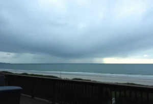
Residents are bracing for varying impacts. Reports suggest that storm surges could begin as early as Wednesday, with the most significant impact anticipated on Thursday. Rainfall predictions show that areas in South Carolina could see between 5 to 10 inches, with localized flooding likely in low-lying spots. In South Carolina, further rain accumulation may bring totals close to 3 inches in coastal areas and even more inland.
Date added stress, Hilton Head Island’s tides are causing a stir! They are expected to reach 7.2 feet early morning and hit 8.6 feet later in the day. Meanwhile, Beaufort will experience similar tidal changes, urging residents to remain alert.
Tornadoes and Winds to Watch For
Additionally, a slight risk of tornadoes has been raised. The South Carolina Emergency Management Division noted that we should keep our eyes peeled for possible tornado activity, especially in specific rain bands linked with the storm. Frank Strait, a state weather liaison, warned that nighttime tornado outbreaks can be particularly dangerous.
Preparation and Safety
For all residents, preparing for Hurricane Helene is critical. Knowing your best shelter locations in advance can help, as warning times can be short. Beaufort County does not have tornado sirens, so consider setting up alerts through various channels like NOAA Weather Radio or Emergency Alert System notifications. Strong winds hitting coastal areas might lead to downed trees and power outages, affecting daily life.
As of mid-morning on Wednesday, schools and government operations in Beaufort County have not closed yet, but the situation is evolving. Georgia’s Governor even declared a State of Emergency for several counties, including Savannah and Tybee Island, highlighting the seriousness of Helene’s approach.
Stay Informed!
As everyone starts stocking up and preparing, remember that the forecast is still changing, so staying informed is crucial. Whether you’re in the Lowcountry or further inland, the rippling effects of this storm will be felt, and taking action now could make all the difference later. Keep your loved ones safe, and monitor updates closely as we navigate this hurricane together.

Author: STAFF HERE HILTON HEAD
The HILTON HEAD STAFF WRITER represents the experienced team at HEREHiltonHead.com, your go-to source for actionable local news and information in Hilton Head Island, Beaufort County, and beyond. Specializing in "news you can use," we cover essential topics like product reviews for personal and business needs, local business directories, politics, real estate trends, neighborhood insights, and state news affecting the area—with deep expertise drawn from years of dedicated reporting and strong community input, including local press releases and business updates. We deliver top reporting on high-value events such as the RBC Heritage golf tournament, Hilton Head Island Wine & Food Festival, and the Gullah Celebration. Our coverage extends to key organizations like the Hilton Head Island-Bluffton Chamber of Commerce and Community Foundation of the Lowcountry, plus leading businesses in tourism and hospitality that power the local economy such as Sea Pines Resort and Sonesta Resort Hilton Head Island. As part of the broader HERE network, including HEREAiken.com, HEREBeaufort.com, HEREChapin.com, HERECharleston.com, HEREClinton.com, HEREColumbia.com, HEREGeorgetown.com, HEREGreenwood.com, HEREGreenville.com, HEREHiltonHead.com, HEREIrmo.com, HEREMyrtleBeach.com, HERENewberry.com, HERERockHill.com, and HERESpartanburg.com, we provide comprehensive, credible insights into South Carolina's dynamic landscape.